
Campus maps through time
"The range of campus maps and original plans, digitised for the first time and made publicly available online, will provide an essential new way for researchers, students and local residents to understand and study the unfolding historical geography of The University of Manchester."
In partnership with the School of Environment, Education and Development, The University of Manchester Library has recently digitised a unique collection of historic documents encompassing original campus maps, development site plans, architectural drawings and historic student guides.
Hosted by Library Digitised Collections, this set of material, drawn from various sources in the Library’s Special Collections and the University Archives, spans the 190-year history of the University and will help to foster engagement with its history and heritage.
This collection covers the early Owens College period, the Victorian-era University, the emergence of the Fallowfield campus of student halls, the building of UMIST and the 1960s expansion of the Education Precinct.
About the project
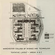 An important way to understand and communicate the complex history of The University of Manchester is through the development of its estate, the construction of notable buildings and the changing shape and overall enlargement of the campus. This story of geographic expansion and change over time of the University (and its various predecessor institutions) can be found in these original campus maps, development plans and publicity booklets.
As demonstrated by the successful Mapping Manchester public exhibition, historic maps, plans and architectural drawings are useful means by which we can communicate our past and potential futures, and which can also provide valuable material for education and research.
The maps and plans are of great value for academic research on the growth and development of city neighbourhoods and higher education campuses, for teaching in geography, planning, architecture and history. They are also critically important for University History and Heritage projects seeking to understand the University’s complex history and engage audiences with our past.
The digitised material encompasses a range of campus maps and site plans spanning different dates, along with richly illustrated reports which include overview maps, building plans and evocative architects’ sketches. Also included are brochures originally published for the opening of key buildings, publicity booklets that document the campus and a fascinating selection of student guides and leaflets, including details of the halls of residences.